Welcome!
Thanks for finding NWI TRAILS! The main component of this website is an interactive Google Map of seven Northwest Indiana bicycle trails. The map is a resource for residents and visitors of the region, showing them opportunities for recreation in the area. Zoom-in to your home, find the nearest trail, call a friend, and take a ride. Happy Pedaling!!
Google Interactive Bicycle Trails Map
How To Use The Map

Map Controls
The map below illustrates seven bike trails in Northwest Indiana. The current base map shows Google Terrain. This can be changed by clicking the drop-down menu in the map's top right corner. Avaliable base maps include: Google Satellite Imagery, Google Hybrid, Google Map, as well as USGS Topo and Aerial maps. When viewing one of these maps, a change in map opacity may be helpful to accentuate the trail's path. This can be manipulated with the drop-down percentage menu in the top right corner. The legend is also movable by dragging the top grey portion of the box to the desired location. Clicking on the name of the trail in the legend will cause the trail to disappear from the map. Re-clicking the name will make it re-appear. For those new to google maps, an overview of controls is provided here.
Trail Information
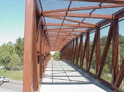
Pointing the mouse over the camera icon along a trail will allow you to see a view of the trail. Clicking on the camera will provide this information PLUS the trail's length and surface.
 |
|
For Additional Trails Information...
Check out these great links from indianatrails.org for additional descriptions, connections, and plans!
Calumet Trail http://www.indianatrails.org/Calumet.htm
Erie Lackawanna Trail http://www.indianatrails.org/Erie_Trail.htm
Iron Horse Heritage Trail http://www.indianatrails.org/Iron_Horse_Heritage_Trail.htm
Marquette Trail http://www.indianatrails.org/Marquette.htm
Oak Savannah Trail http://www.indianatrails.org/Oak_Savannah_Trail.htm
Prairie Duneland Trail http://www.indianatrails.org/Prairie_Duneland_Trail_Portage.htm
© Jordan Isringhaus 2008
